 Guest
Guest
Chapter:
EDM
1. What is error in feet for ordinary levelling for location and construction surveys?
2. Find value of R.L, if B.M = 400 m, B.S = 1.142 m, F.S = 2.121 by using rise and fall method?
3. If staff at station point is not held vertically, R.L at observation would be __________
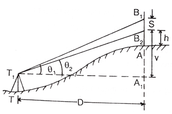
4. In following figure, D = ______
5. When an instrument is at P staff readings on P is 1.824 and on Q is 2.748. When instrument at Q staff readings on P is 0.928 and Q is 1.606. Distance between P and Q is 1010 mts. R.L. of P is 126.386. Find true R.L. of Q?
6. The object glass provides a virtual inverted image in front of eyepiece which in turn magnifies image to produce a real erect image in surveyors telescope.
7. Stadia method is based on principle that ratio of perpendicular to base is constant.
8. Horizontal line departs from a level surface because of _________
9. Surveyor’s telescope is an adaptation of Kepler’s telescope.
10. A light house is visible just above horizon at a certain station at sea level. The distance between station and light house is 10 km. Find height of light house?
All Chapters
View all Chapter and number of question available From each chapter from Surveying
Introduction to Surveying
Introduction to Surveying
Chain Surveying & The Compass
Chain Surveying & The Compass
Compass Traversing & Traverse Surveying
Compass Traversing & Traverse Surveying
Levelling
Levelling
Contouring
Contouring
The Theodolite & Theodolite Traversing
The Theodolite & Theodolite Traversing
Plane Table Surveying
Plane Table Surveying
Calculation of Area, Measurement of Volume & Permanent Adjustments of Levels
Calculation of Area, Measurement of Volume & Permanent Adjustments of Levels
Area Computation & Tacheometric Surveying
Area Computation & Tacheometric Surveying
EDM
EDM
Curve Surveying
Curve Surveying
Triangulation
Triangulation
Survey Adjustments and Theory of Errors
Survey Adjustments and Theory of Errors
Field Astronomy
Field Astronomy
Photogrammetric Surveying
Photogrammetric Surveying
Remote Sensing
Remote Sensing
Geographic Information System (GIS) & Topographic Maps
Geographic Information System (GIS) & Topographic Maps
Global Positioning System (GPS)
Global Positioning System (GPS)
Hydrographic Survey
Hydrographic Survey
Project Survey
Project Survey
Surveying Important Questions
Surveying Important Questions
Topics
This Chapter EDM consists of the following topics
Levelling
What is error in feet for ordinary levelling for location and construction surveys?
Find value of R.L, if B.M = 400 m, B.S = 1.142 m, F.S = 2.121 by using rise and fall method?
If staff at station point is not held vertically, R.L at observation would be __________
In following figure, D = ______
