 Guest
Guest
Chapter:
1. Explain Classification of surveying.
Surveying is primarily classified as under:
- Plane surveying
- Geodetic Surveying
Plane Surveying is that type of surveying in which the mean surface of the earth is considered as a plane and the spheroidal shape (curvature of the earth) is neglected. All triangles formed by survey lines are considered plane triangles. The level line is considered straight and all plumb lines are considered parallel. In everyday life were are concerned with small portion of earth’s surface and the above assumptions seems to be reasonable in light of the fact that the length of an arc 12 kilometers long lying in the earth’s surface is only 1cm greater than the subtended chord and further that the difference between the sum of the angles in a plane triangle and the sum of those in a spherical triangle is only one second for a triangle at the earth’s surface having an area of 195 sq. km.
Geodetic Surveying is that type of surveying in which the shape of the earth is taken into account. All lines lying in the surface are curved lines and the triangles are spherical triangles. It therefore, involves spherical trigonometry. All Geodetic surveys include work of larger magnitude and high degree of precision. The object of geodetic survey is to determine the precise position on the surface of the earth, of a system of widely distant points which form control stations to which surveys of less precision may be referred.
Classification of surveying
Surveys may be secondarily classified under no. of headings which define the uses or purpose of resulting maps.
Classification based upon nature of field:
There are three types of surveying based upon the nature of field which are as follows:
- Land Surveying: It can be further classified as i) Topographical survey ii) Cadastrial Survey and iii) City Survey. It generally deals with natural or artificial features on land such as rivers, streams, lakes, wood, hills, roads, railways, canals, towns, water supply systems, buildings & properties etc.
- Marine Surveying: Marine or hydrographic survey deals with bodies of water for purpose of navigation, water supply, harbour works or for determination of mean sea level. The work consists in measurement of discharge of streams, making topographic survey of shores and banks, taking and locating soundings to determine the depth of water and observing the fluctutations of the ocean tide.
- Astronomical Surveying: The astronomical survey offers the surveyor means of determining the absolute location of any point or the absolute location of and direction of any line on the surface of the earth. This consists in observations to the heavenly bodies such as the sun or any fixed star.
Classification based on object:
Based on object, there are four types of surveying which are as follows:
- Geological Surveying
- Mine Surveying
- Archaeological surveying
- Military surveying
Classification based on instruments used:
Based on various types of instruments used, surveying can be classified into six types.
- Chain surveying
- Compass surveying
- Plane table surveying
- Theodolite surveying
- Tacheometric surveying
- Photographic surveying
Classification based on methods used:
Based on methods adopted, surveying can be categorized into:
- Triangulation surveying
- Traverse surveying
2. Explain entry into survey field book and level book.
Field Book:
- The book in which the chain or tape measurements are entered is called the field book.
- It is an oblong book of size about 20 cm x 12 cm and opens lengthwise.
- The main requirements of the field book are that it should contain good quality stout opaque paper.
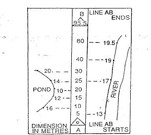
In case of survey field book (chain survey) entry data is started from bottom page of field book to top in upward direction while in the case of the level book entry data is started from top to bottom in downward direction. The format of level book and field book is shown below:

3. Explain Principle of surveying.
Surveying is the art of determining the relative positions of points on, above or beneath the surface of the earth by means of direct or indirect measurements of distance, direction and elevation. Leveling is a branch of surveying the object of which is to find the elevations of points with respect to a given or assumed datum and to establish points at a given elevation or at different elevations with respect to a given or assumed datum.
The main objectives of surveying can be listed as follows:
a. To determine the relative position of various points above, on, or beneath the surface of the earth.
b. To take the linear measurements and angular measurements between various points.
c. To prepare the plans and maps i.e. for the representation of a measured plot of the area on a horizontal plane.
d. To provide a basis for civil engineering construction works and activities.
2. Principles of Surveying
In general, surveying is based upon a number of principles (or guidelines) which can be listed as follows:
a. Working from Whole to Part
b. Location of Point by Measurement from Two Points of Reference
c. Consistency of Work
d. Independent Check
e. Safeguarding
f. Economy of accuracy and its influence on choice of Equipments
g. Honesty
a. Working from Whole to Part
According to this principle the whole area is first enclosed by main stations. (i.e. controlling stations and main survey lines (i.e. controlling lines). The area is then divided into a number of parts by forming well-condition triangles. The main survey lines are measured with high precision. Then sides of triangles are measured. The purpose of this process of working is to prevent accumulation of error. During this procedure if there is any error in the measurement of any side of triangle then it will not affect the whole work. The error can always be detected and eliminated.
Example: This principle is essential in International Boundary Locating, Property Boundary Locating, etc.
b. Location of Point by Measurement From atleast Two Points of Reference
On the basis of this principle, the relative position of the desired points to be surveyed must be located by taking the measurement from at least two (preferably three) points of reference, such that the position of the reference points has already been fixed previously.
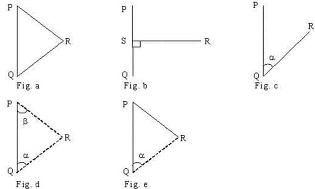
Figure: Location of a Point from Two Reference Points
Let R be the point whose location is to be fixed and P and Q be the two reference points whose positions have already been fixed. The position of the point R can be determined by any one of the above-shown methods in the figure.
c. Consistency of Work
The survey should be consistence (i.e. it should be of same accuracy and precise throughout). If any portion of survey is erogenous then in spite of other remaining part more accuracy that accuracy is of no used as bad quality survey at any part of work ruin the whole survey. But in modern method of survey network adjustment allow for some flexibility in the application of this principle and it is not always necessary for all of a particular stage of survey to be of the same quality but this manipulation depend on the condition and requirement. availability of fund, time and scale of drawing.
d. Independent Check
It says that all the measurement should be checked in such a way that an error will be appeared (i.e. no error is left undetected) before survey is completed. All the measurement should be cross checked by measuring from different points or perspective. (e.g. for a rectangular block measurement the four sides are measured and its diagonal are also measured forming triangles and equating the diagonal to check accuracy. Also Pythagorus theorem and sine law etc. can be used to ascertain the accuracy. Some time measurement from another reference points are also taken to locate the same point by two different measurement.
e. Safeguarding
Since survey can be an expensive process, every sensible precaution should be taken to ensure that the work is not compromised. Safeguarding is concerned with the protection of the work. Observations which are written down in the field must be in a permanent, legible, unambiguous and easily understood from so that others may make good sense of work. Observation and other data should be duplicated at early stage of surveying so that if something happens to the original work the information is not lost.f. Economy of accuracy and its influence on choice of Equipments
Survey work is usually described as being to a certain standard of accuracy. It is always better to achieve higher degree of precision and accuracy than aimed. The degree of accuracy achieved depends on the instrument used time and effort applied to any survey work. But as we know the expense increase is directly proportional to the accuracy achieved. So the standard accuracy attained in field must be in keeping with the size in of ultimate drawings. (i.e. achieving higher accuracy investing much money on small work is useless) and also selecting much advanced instrument for measuring very small area is also worthless. So selection of instrument and accuracy achieved should be according to work.
g. Honesty
Honesty is essential in booking notes in the field and when plotting and computations in the office. There is nothing to be gained from cooking the survey or altering dimension so that points will tie-in on the drawing. It is utterly unprofessional to betray such trust at each stage on the survey.
4. Explain Scales.
A scale is the ratio of the distance marked on the plan to the corresponding distance on the ground.
Types of Scales are generally classified as large, medium and small.
- Large scale : 1 cm = 10 m or less than 10 m.
- Medium scale : 1 cm = 10 m to 100 m.
- Small scale : 1 cm = 100 m or more than 100 m.
Representation of a Scale :
A. Engineer’s scale : 1 cm = 50 m
B. Representative Fraction (R.F) :
It is the ratio of the distance on the map to the corresponding distance on the ground taken as same units. Scale of 1 cm = 50 m, 1 cm on the map represents 50 m (5000 cm) on the ground. Therefore, the representative fraction (R.F.) is 1/5000 or 1: 5000.
C. Graphical scale :
A graphical scale is a line drawn on the map so that its map distance corresponds to a convenient units of length on the ground.
It has the advantage over the numerical scales that the distances on the maps can be determined by actual scaling even when the map has shrunk.
Types of Measuring Scales in Surveying
Plane Scale :
It is possible to measure two successive dimensions only.
Diagonal Scale :
It is possible to measure three successive dimensions.
Chord scale :
It is used to set out angles without using a protractor.
Vernier Scale :
It is a device for measuring accurately the fractional part of the smallest division on a graduated scale. It divided into,
- Direct Vernier : ‘n’ divisions on the vernier scale are equal in length to (n – 1) divisions on the main scale. Thus ‘n’ divisions of vernier = {n -1) of main scale :
∴ n ‘v’ = (n-1) ‘s’ or v = {(n-1)/n}*s
Where, n = total No. of divisions on vernier scale, v = length of one division on the vernier, s = length of one division on the main scale. The least count (L.C) is, therefore given by
L.C = s – v.
L.C = s – {(n-1)/n}*s.
L.C = s/n.
The verniers, which extend in the same direction graduation of their main scale increases and smallest division is shorter than the in which the smallest division of their main scale, are called as direct vernier.
- Retrograde Vernier :
- The verniers, which extend in the opposite direction of their main scale increases and smallest division is longer than the smallest division of their main scales, are called as retrograde vernier. ‘n’ divisions of the vernier scale are equal to ‘(n+1)’ divisions on the main scale.
∴ n ‘v’ = (n+1) ‘s’
- Extended Vernier : ‘n’ divisions of the vernier scale are equal in length to (2n – 1) divisions of the main scale. Therefore,
∴ n ‘v’ = (2n-1)s
∴ v = {(2n-1)/n}s - Double Vernier : It is used when the graduations on the main scale are numbered in both directions. It is a combination of both direct and retrograde verniers.
- Double folded vernier : Its length is half of corresponding double verniers – economy of space.
Micro scale :
It is a device which enables a measurement to be taken to a still finer degree of accuracy.
Note:
Least count (LC):- The difference between smallest division of main scale & vernier scale is scale by called least count. It is obtained by dividing the value of one division of primary the total number of divisions of the vernier scale. If S is the one division of primary scale and n is the total number of divisions of vernier scale;
then
Least count `=S/n`
5. Explain difference between plan and map.
In simple words, the map is a topographical representation of various elements, location, places, regions etc. all the information present on maps can be seen on site. The map is a study of the whole location. It is given information about important points.
The plan is a dimensional representation place, region, structure, building with various detail information. It also includes hidden data and diagrams. It gives detailed information about small areas in symbolic forms.
Plan | Map |
| A plan is the graphical representation, to some scale, of features on, near or below the surface of the earth as projected on horizontal plane. | If the scale of the graphical representation on a horizontal plane is small, the plan is called a map. |
| A plan is drawn on a large scale. | A map is drawn on a small scale. |
| Scale: 1 cm = 10 m or < 10 m | Scale: 1 cm = 100 m or > 100 m |
| On a pan, generally horizontal dist’s & directions are shown. | On a topographic map, vertical dist’s (elevations) are also shown by contour lines. |
| A plan is drawn for small area. e.g. – Plan of house, plan of bridge | A map is drawn for large area. e.g. – Map of Area |
6. Write down difference between plane and geodatic surveying.
Difference in table format:
PLANE SURVEYING | GEODETIC SURVEYING | |
| 1 | The earth surface is considered as plain surface | The earth surface is considered as curved surface |
| 2 | The Curvature of the earth is ignored | The Curvature of the earth is taken into account |
| 3 | Survey accuracy is low | Survey accuracy is high |
| 4 | Line joining any two stations is considered to be straight | The line joining any station is considered as spherical |
| 5 | The triangle formed by any three points is considered as plain | The triangle formed by any three points is considered as spherical |
| 6 | Carried out for a small area of <260 k`m^2` | Carried out for area of >260 k`m^2` |
| 7 | Plane surveying uses normal instruments like chain, measuring tape, theodolite etc. | Geodetic surveying uses more precise instruments and modern technology like GPS. |
7. Explain Selection of Suitable Method of surveying.
It depends upon the types of area to be served. It also considers the effect of magnetic field due to electric current. For example, chain survey is used for the small area having fairly level ground and compass survey is used where there is no effect of electric field. Plane table survey is used for the area having open ground. Tacheometric survey is used for broken ground.
Plane surveying is suitable for a survey of small areas (up to 196 Sq. Km) where the earth's curvature does not affect the results and is conducted in small areas.
Chain survey is suitable in the following cases:
- The area to be surveyed is comparatively small
- The ground is fairly level
- The area is open and
- Details to be filled up are simple and less
Compass surveying is recommended when the area is large, undulating and crowded with many details. It is not recommended for areas where the local attraction is suspected due to the presence of a magnetic substance.
Tacheometry surveying is best suited when obstacles such as steep and broken ground, deep ravines, stretches of water or swamps are me.
The plane tabling is generally adapted for surveys in which high precision is not required. It is mainly employed for small-scale or medium size mapping.
