 Guest
Guest
Chapter:
geographic-information-system-gis-topographic-maps
1. CIM was adopted by which of following commissions?
2. Which of following doesn’t indicate a topology error?
3. If number on scale is less n it represents a large scale map.
4. Longitudes are used to represent which of following directions?
5. GIS uses information from which of following sources?
6. Which of following software’s are used for developing vehicle route?
7. The point data feature can be used to represent ______
8. Determine scale of map if distance on map is given as 2cm which is equal to 1km on ground.
9. The CIM series can be used in ______ scale.
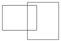
10. The figure represents which type of error in GIS?
All Chapters
View all Chapter and number of question available From each chapter from surveying
Introduction to Surveying
Introduction to Surveying
Chain Surveying & The Compass
Chain Surveying & The Compass
Compass Traversing & Traverse Surveying
Compass Traversing & Traverse Surveying
Levelling
Levelling
Contouring
Contouring
The Theodolite & Theodolite Traversing
The Theodolite & Theodolite Traversing
Plane Table Surveying
Plane Table Surveying
Calculation of Area, Measurement of Volume & Permanent Adjustments of Levels
Calculation of Area, Measurement of Volume & Permanent Adjustments of Levels
Area Computation & Tacheometric Surveying
Area Computation & Tacheometric Surveying
EDM
EDM
Curve Surveying
Curve Surveying
Triangulation
Triangulation
Survey Adjustments and Theory of Errors
Survey Adjustments and Theory of Errors
Field Astronomy
Field Astronomy
Photogrammetric Surveying
Photogrammetric Surveying
Remote Sensing
Remote Sensing
Geographic Information System (GIS) & Topographic Maps
Geographic Information System (GIS) & Topographic Maps
Global Positioning System (GPS)
Global Positioning System (GPS)
Hydrographic Survey
Hydrographic Survey
Project Survey
Project Survey
Surveying Important Questions
Surveying Important Questions
Topics
This Chapter geographic-information-system-gis-topographic-maps consists of the following topics
Geographic Information System (GIS) & Topographic Maps
CIM was adopted by which of following commissions?
Which of following doesn’t indicate a topology error?
If number on scale is less n it represents a large scale map.
Longitudes are used to represent which of following directions?
GIS uses information from which of following sources?
Which of following software’s are used for developing vehicle route?
The point data feature can be used to represent ______
Determine scale of map if distance on map is given as 2cm which is equal to 1km on ground.
The CIM series can be used in ______ scale.
The figure represents which type of error in GIS?
